|
TerrainLab is a distributed hydrological model, which is
used to simulate the detailed spatial and temporal variation
patterns of evapotranspiration (ET). This model is based on
the physically based, distributed hydrology-vegetation model
of Wigmosta et al. (1994). The original Wigmosta's model provides
an effective system to consider the flow of water in the soil-plant-atmosphere
continuum, and is similar to many other models (Beven and
Kirkby, 1979; Band et al., 1993; Paniconi and Wood, 1993).
In addition, the model also includes a modeling framework
in which the water flow is simulated among neighboring spatial
units in a regular grid on varying topography. This framework
is particularly suitable for applications to remote sensing
data as pixels in remote sensing images can be treated as
the spatial units.
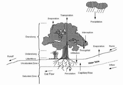
Model Structure
Basic model simulations of the physical and biological processes
are made at the pixel scale. According to the need of simulating
hydrological processes, a pixel is vertically divided into
five strata, i.e. overstorey, understorey, litter or moss
layer, soil unsaturated zone, and soil saturated zone (Fig.
1).
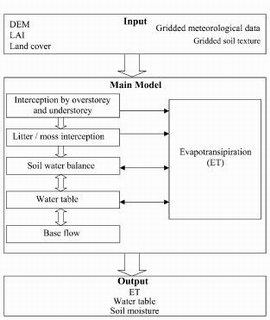
The framework of the model, separated into input, main model
and output domains, is illustrated in Fig. 2. Precipitation,
solar radiation, topographic parameters, land cover, leaf
area index (LAI), and soil properties are the major inputs
to the model. All input parameters are spatially resampled
to every pixel. The use of remotely derived parameters, such
as LAI and land cover, allows for process-based modeling of
evapotranspiration (ET) using the Penman-Monteith equation
(Monteith, 1965) as well as other hydrological and energy
components such as precipitation interception and its evaporation.
The major outputs are ET, soil moisture, and water table.
Horizontally, a moving window of 3 X 3 pixels is used to estimate
the lateral, saturated, base flow according to topography
and water table (Fig. 3).
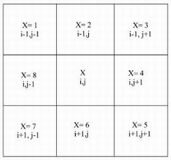
At each daily time step, this window is moved across the
modeling domain to update the water table of each pixel as
a result of the net lateral base flow in all eight cardinal
directions. As the hydraulic conductivity in saturated soils
is generally less than 1 m per day (Ward and Robinson, 2000),
the daily time step is adequate for estimating the lateral
water flow for 30 m X 30 m pixels.
Several major assumptions are made in the model: (i) all
physical and biological properties are homogeneous within
the basic modeling unit, i.e. the pixel; (ii) soil texture
is vertically invariant (although structure changes with depth);
(iii) as the model is generally run at daily time steps, a
sinusoidal diurnal variation pattern of the incident solar
radiation is assumed in deriving daily radiation components;
and (iv) at the daily time step, surface runoff does not occur
until the whole soil profile is saturated.
|